#Geospatial Data
Explore tagged Tumblr posts
Visit Tumblr Blog
Explore Tumblr blogs with no restrictions, modern design and the best experience.
Last Seen Tumblr Blogs


Fun Fact
In 2020, 44% of users from Denmark used Tumblr daily.
Text
How to Find, Evaluate, and Effectively Use Geospatial Data in GIS: A Step-by-Step Guide
In today's data-driven world, geospatial data has become essential for businesses, researchers, and governments to make informed decisions. Whether you're working in urban planning, environmental science, logistics, or other fields, the ability to locate, evaluate, and use geospatial data effectively in GIS (Geographic Information Systems) can make a significant impact. Here’s a step-by-step guide to help you through the process of working with geospatial data to maximize its potential in your GIS projects.
Step 1: Understanding Geospatial Data and Its Types
Before diving into finding geospatial data, it's essential to understand its forms and applications. Geospatial data represents geographic information, typically in terms of latitude, longitude, and elevation. The data comes in two main types:
Raster Data: Composed of grid cells or pixels, such as satellite imagery or aerial photographs.
Vector Data: Includes points, lines, and polygons, used to represent specific features like roads, city boundaries, and infrastructure.
Understanding which type of data is needed will set the foundation for your project.
Step 2: Identifying Your Data Needs
Define the scope and objectives of your project. Questions to ask include:
What area does the project cover? Identify the geographic scope.
What data variables are required? For example, temperature, elevation, or land cover types.
How recent should the data be? Some projects require real-time data, while others may use historical data.
What resolution or detail is needed? Higher resolution is useful for local analyses, while lower resolution might be sufficient for regional or global projects.
With this information, you can start searching for the appropriate data sources.
Step 3: Finding Reliable Sources of Geospatial Data
Many public and private organizations provide access to geospatial data. Here are some popular sources:
Government Databases:
USGS Earth Explorer: Excellent for US-specific data, particularly for geological and topographic information.
NASA Earth Data: Free datasets for satellite imagery and climate information.
Copernicus Open Access Hub: Provides data from the European Union's Sentinel satellites.
Global Databases:
OpenStreetMap (OSM): A community-driven mapping platform, providing access to vector data like roads and landmarks.
Google Earth Engine: A robust platform offering global-scale geospatial datasets and processing capabilities.
Natural Earth: Free vector and raster map data at different scales for global use.
Commercial Data Providers:
DigitalGlobe and Planet Labs: These companies offer high-resolution satellite imagery and geospatial data, typically on a paid basis.
For more specialized datasets, reach out to academic institutions or industry-specific organizations. Once you’ve identified potential sources, move on to evaluating the data.
Step 4: Evaluating Geospatial Data Quality
Once you’ve sourced your data, it's critical to assess its quality to ensure it meets your project's requirements. Consider the following factors:
Accuracy: Ensure the data aligns with real-world measurements. Vector data should match the geographic reality, and raster data should align with known resolutions.
Timeliness: Is the data up-to-date, or is historical data sufficient? Projects that monitor trends over time might require datasets spanning multiple years.
Completeness: Verify that the dataset covers your entire area of interest without gaps.
Reliability: Look for metadata, which provides details about data collection methods, processing, and sources. Reliable data is usually backed by documentation.
Compatibility: Ensure the data format (e.g., shapefile, GeoTIFF, KML) is compatible with your GIS software. Most GIS platforms support common formats, but it’s best to double-check.
Evaluating data quality can help avoid costly errors and inaccuracies during analysis.
Step 5: Processing and Cleaning Geospatial Data
Geospatial data often requires cleaning and processing to prepare it for analysis:
Projection and Coordinate Systems: Ensure all data layers use the same coordinate system. Misaligned layers can lead to inaccurate spatial analyses.
Data Transformation: Adjust formats as needed to fit your analysis. For instance, raster data might need to be reclassified for thematic mapping, while vector data may require simplification.
Error Correction: Check for and correct errors like missing values or outliers.
Resampling: For raster data, resampling may be necessary to match different resolutions across datasets.
These steps prepare your data to integrate seamlessly in GIS, minimizing errors during analysis.
Step 6: Conducting Geospatial Analysis in GIS
Once the data is clean and ready, GIS provides powerful tools to analyze and interpret it. Here are a few common types of geospatial analysis:
Spatial Analysis: Use tools like overlay, buffering, and spatial joins to find relationships between different datasets. For example, analyze how close schools are to certain environmental hazards.
Temporal Analysis: For time-based data, use temporal analysis to observe changes over time. This is useful for tracking urban growth, deforestation, or climate patterns.
Statistical Analysis: GIS platforms offer statistical tools that allow you to quantify spatial patterns, helping in hotspot analysis or population density mapping.
Predictive Modeling: Create models that use spatial data to predict future trends, such as urban sprawl or wildlife habitat migration.
Each type of analysis provides unique insights to support data-driven decisions.
Step 7: Visualizing and Presenting Geospatial Data
Good visualization makes data insights accessible. Use GIS tools to create clear, informative maps, and customize visualization elements:
Layering and Symbology: Adjust colors, symbols, and labels to represent different data types clearly. For example, use blue for water bodies and green for vegetation.
Classification: Group data into meaningful categories, like low, medium, and high elevation, for better interpretation.
Legends and Scale Bars: Include legends, scale bars, and north arrows to make maps easy to read and understand.
Presenting data in visually appealing formats enhances comprehension and effectively communicates your findings to stakeholders.
Step 8: Sharing and Storing Your Geospatial Data
Once your analysis and visualization are complete, you may want to share it with others or store it for future use:
Export Options: Most GIS platforms allow you to export maps in various formats, such as PDFs, JPGs, or online interactive maps.
Data Sharing Platforms: Platforms like ArcGIS Online and QGIS Cloud make it easy to share data and maps with collaborators.
Data Storage: Geospatial data files can be large, so store them in a secure location. Cloud storage solutions like Google Drive, Dropbox, or Amazon S3 provide scalable options.
Following these steps ensures that your data is preserved and accessible for future projects.
Final Thoughts
Working with geospatial data requires a blend of technical skills and attention to detail, but the potential insights are invaluable. Choose experienced partner like Magnasoft who hold decades of experience, industry connections, and advanced tools. From sourcing quality data to advanced analysis and visualization, Magnasoft supports every stage of your GIS project, empowering you to make data-driven decisions confidently and effectively.
Start your next GIS project with Magnasoft and unlock the power of precise, reliable geospatial data! For more insights and tips, follow Magnasoft’s updates as we continue to lead in GIS solutions.
0 notes
Text

Optimizing Networks for Efficiency: Strategies and Best Practices
In the ever-evolving landscape of telecoms, network optimization is now a focus for service providing companies searching to enhance performance and offer extraordinary service quality.
The Role of Fiber Management
Fiber Management is a cornerstone of current network optimization. As fiber optic networks become the backbone for worldwide connectivity, managing these assets efficiently is important. Fiber management is the systematic management and control of fiber optic cable, connectors and the associated infrastructure to ensure uninterrupted data transmission.
Click to read more.
Originally published: https://leptonsoftware.com/optimizing-networks-for-efficiency-strategies-and-best-practices/
#lepton maps#lepton software#gis mapping#location intelligence#fiber network#network optimization#telecom solutions#gis#maps#3d map#gis tool#data visualization#geospatial data#geo-fencing#geospatial intelligence#fiber management#fiber planner#fiber planning#fiber design#smartinventory#networkaccess#leptonsoftware
0 notes
Text
FOI release: discussion paper on Measuring Impact of the Geospatial Commission
Post: 8 August 2024
New blog post on my website:
FOI release: discussion paper on Measuring Impact of the Geospatial Commission
0 notes
Text

When the only thing you need after a 10h work schedule is to know the distance between two imaginary towns so you can accurately calculate the time to travel between them given the average horse speed so that you can accurately reference this in one line of a fic

4 notes
·
View notes
Text
i really thought the society & sustainability class would be my fave this quarter but NAY. map city baby.
#my prof for that class is way cooler & better at teaching#AND they said we could make shit up for our final project as long as we demonstrate an understanding#of geospatial data and arcGIS#the example they gave was setting parameters for preferred dragon dens and mapping where one might like to live#anyway im also learning just like. way more#i think i prefer working with data over the more... social science side of environmental science#the social science aspect is ofc important but thats not really what im in school for. i dont think i need a degree in that to understand i
3 notes
·
View notes
Text
Why Atom Aviation is the Leading LiDAR Survey Company in India

In today’s fast-paced world, the demand for precise and reliable data is growing across various industries. One of the most advanced technologies transforming survey work is LiDAR (Light Detection and Ranging). When it comes to LiDAR survey services in India, Atom Aviation stands out as a top choice.
What is LiDAR Surveying?
LiDAR is a cutting-edge technology that uses laser light to measure distances and create high-precision, 3D representations of landscapes, structures, and other objects. The accuracy of LiDAR makes it a crucial tool in industries such as construction, agriculture, forestry, and urban planning.
Why Choose Atom Aviation for LiDAR Surveying?
Atom Aviation, a renowned LiDAR survey company in India, has established a solid reputation for offering top-notch surveying services. Here are a few reasons why Atom Aviation is the preferred choice for businesses seeking reliable LiDAR surveys:
1. Expertise and Experience
Atom Aviation has years of experience in delivering precise and comprehensive LiDAR data. Their team of skilled professionals is well-versed in using advanced drone technology, ensuring that surveys are completed efficiently and accurately. Whether it’s large-scale topographic mapping or detailed infrastructure analysis, Atom Aviation is equipped to handle it all.
2. State-of-the-Art Technology
As a leader in the field, Atom Aviation leverages the latest drone-based LiDAR systems that capture data quickly and accurately. These high-tech systems can cover vast areas and provide detailed topographic information, which is essential for making well-informed decisions in a wide range of industries.
3. Cost-Effective Solutions
Atom Aviation not only offers high-quality LiDAR surveys but also ensures that their services are budget-friendly. By using drones for LiDAR surveys, they reduce the need for costly manual data collection methods, ultimately saving businesses time and money.
4. Quick Turnaround Time
One of the major benefits of using drone-based LiDAR is the speed at which data can be collected and processed. Atom Aviation guarantees a fast turnaround time without compromising on the quality of the results. This makes it an excellent option for businesses that need survey results promptly.
5. Wide Range of Applications
Whether you’re in the construction industry, need forest mapping, or are working on a land development project, Atom Aviation provides LiDAR surveying solutions tailored to your specific needs. The versatility of their services ensures that businesses across various sectors can benefit from accurate, actionable data.
Industries Benefiting from LiDAR Surveying
Construction: LiDAR data helps with precise mapping and 3D modeling, aiding in construction planning and project management.
Agriculture: LiDAR surveys can assist in crop monitoring, soil health analysis, and irrigation planning.
Forestry: LiDAR can create detailed maps of forests, identifying tree heights, density, and canopy coverage.
Urban Planning: Cities can utilize LiDAR data for infrastructure mapping, flood risk assessments, and urban development projects.
Why LiDAR Surveys are Essential
Traditional surveying methods often require manual labor and long hours, making them less efficient and more prone to errors. LiDAR technology, however, provides highly accurate and reliable data while reducing the time and cost involved. By choosing a LiDAR survey company in India like Atom Aviation, businesses can enjoy faster, more precise results that are essential for the success of any project.
Conclusion
In a world where precision and efficiency are crucial, Atom Aviation remains one of the most trusted names in LiDAR surveying in India. Their innovative approach, advanced technology, and commitment to delivering high-quality results make them the go-to company for businesses seeking reliable LiDAR survey solutions.
If you are looking to take your project to the next level, don’t hesitate to contact Atom Aviation today and explore how their LiDAR surveying services can help you achieve accurate, actionable insights.
#LiDAR Surveying#LiDAR Mapping#Geospatial Solutions#Accurate Mapping#LiDAR Technology#Surveying Services India#LiDAR Data Acquisition#3D Mapping India#LiDAR Survey Company#Top LiDAR Companies India#Precision Mapping#LiDAR for Surveying#Geospatial Data Services#Mapping Solutions India#LiDAR Experts
1 note
·
View note
Text
Making Maps now at makingmaps.substack.com
#Cartography#data analytics#Denis Wood#Geographic Information Systems#geospatial#information design#John Krygier#Making Maps#maps
0 notes
Text
Harnessing the Power of GIS Data for SEO: Transforming Digital Marketing Strategy
Harnessing the Power of GIS Data for SEO: Transforming Digital Marketing Strategy
Having recently completed comprehensive training in Geospatial Data Collection, Analysis & Interpretation using GIS Technology, I’ve discovered fascinating intersections between my established background in SEO and digital marketing and the powerful capabilities of geospatial analysis. This educational journey, covering everything from fundamental GIS concepts to advanced geospatial analysis and…
#AI-Geospatial#Business-Intelligence#Digital-Marketing-Strategy#Geospatial-Analytics#GIS-Data-Analysis#GIS-Marketing#Local-SEO-Optimization#Location-Intelligence#Marketing-Technology#Spatial-SEO
0 notes
Text
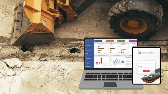
Road Condition Monitoring System(RCMS): Enhancing Efficiency with AI-Powered Solutions
The quality and sustainability of road infrastructure play a pivotal role in societal development, economic growth, and the safety of communities. To address the challenges of road construction and maintenance, advanced digital tools such as Road Condition Monitoring Systems (RCMS) are becoming indispensable. Leveraging technologies like AI-powered pothole detection, data analytics, and interactive visualization, RCMS ensures efficient planning, monitoring, and maintenance of road networks.
#ai and gis road monitoring solutions#geospatial road management solutions#geospatial road monitoring system#gis based pothole mapping and detection#gis based road condition monitoring system#gis based road inspection software#gis based road survey solutions#gis data analysis for road monitoring#gis mapping for road condition analysis#gis road maintenance solutions#land management system#gis tools for road condition assessment#pothole detection using gis technology#real time road condition monitoring gis#road condition assessment using gis#road condition monitoring using gis#road infrastructure monitoring with gis#road maintenance gis software#road safety monitoring with gis systems#road surface monitoring with gis#smart road condition monitoring gis
0 notes
Text
High Water Ahead: The New Normal of American Flood Risks
According to a map created by the National Oceanic and Atmospheric Administration (NOAA) that highlights ‘hazard zones’ in the U.S. for various flooding risks, including rising sea levels and tsunamis. Here’s a summary and analysis: Summary: The NOAA map identifies areas at risk of flooding from storm surges, tsunamis, high tide flooding, and sea level rise. Red areas on the map indicate more…

View On WordPress
#AI News#climate forecasts#data driven modeling#ethical AI#flood risk management#geospatial big data#News#noaa#sea level rise#uncertainty quantification
0 notes
Text
Dictionary of GIS Terms

Aerial Photography Mapping: The creation of maps based on the interpretation and analysis of aerial photographs, utilizing differences in vantage points and angles to construct detailed representations of the Earth’s surface for planning and analysis.
Cartography and Map Design: The art, science, and technology of creating maps, involving the representation of spatial information visually in order to communicate geographic data effectively and accurately.
Climate Change Mapping: The process of using geographic data and mapping technologies to illustrate and analyze the effects of climate change, including rising temperatures, changing precipitation patterns, and extreme weather events.
Consulting Service: Geospatial consulting services offer expert guidance on the strategic implementation and use of geospatial technologies. This includes Presales support, QA&QC, Staffing, Onshore and offshore support, Proof of support and Business process evaluation.
Data Services: In the context of geospatial solutions, data services refer to the processes and technologies used for managing, storing, retrieving, and distributing geospatial data, facilitating decision-making processes across. It comprises data conflation, data standardization, data management across different sectors.
Environmental Geospatial Studies: The application of geospatial technologies and analytical methods to environmental science, studying spatial patterns and processes affecting ecosystems, biodiversity, climate change, and natural resource management.
Enterprise GIS Framework: An enterprise GIS framework is an integrated approach to managing and utilizing geographic information throughout an organization. It enables the sharing of GIS resources, data, and applications across different departments, improving collaboration and efficiency.
Geographic Coordinate Systems: Frameworks that utilize latitude and longitude to pinpoint precise locations on the Earth’s surface, enabling accurate mapping and navigation worldwide.
Geographic Data Visualization: The technique of representing spatial data through graphical forms, including maps and 3D models, to help users understand geographic patterns, relationships, and trends more effectively, enhancing the interpretability of complex spatial information. Digital Terrain Model (DTM), Digital Elevation Model (DEM) are important 3D models to determine the type of terrain and assets.
Geographic Information Science Education: The academic field focused on teaching the principles, technologies, and applications of geographic information systems, including data collection, analysis, and visualization techniques.
Geofencing Technologies: Digital tools that create defined virtual perimeters around real-world geographic areas, enabling automated alerts or actions when objects enter or leave those boundaries.
Geospatial Big Data Analytics: The analysis of large volumes of geographic data from various sources to discover patterns, trends, and insights, supporting complex decision-making processes.
Geospatial Cloud Computing: This concept involves leveraging cloud technology to store, process, and manage geospatial data, enabling scalable and efficient access to GIS resources and data analysis capabilities from anywhere.
Geospatial Data Integration: The merging of geographical data from diverse sources into a coherent dataset, often involving the alignment of different coordinate systems, formats, and data models, to create a comprehensive spatial representation for analysis and decision-making.(Read More…)
#Consulting Service#Data Services#geospatial solutions#Environmental Geospatial Studies#GIS Application
0 notes
Text
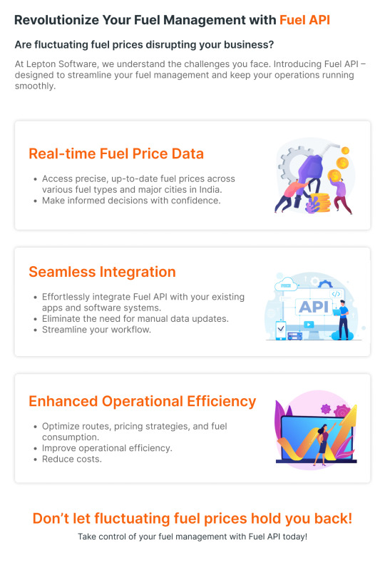
Revolutionize your Fuel Management with Lepton Maps Fuel API
Get Real-Time Fuel Price, Seamless Integration, Enhanced Operational Efficiency and Accurate Data. Click to learn more: https://leptonmaps.com/docs/nearby/fueling_stations
#lepton maps#lepton maps apis#map apis#fuel api#fuel apis#fue station data#real time data#geospatial data#datasets
0 notes
Text
Meta-learning to find every needle in every haystack - Technology Org
New Post has been published on https://thedigitalinsider.com/meta-learning-to-find-every-needle-in-every-haystack-technology-org/
Meta-learning to find every needle in every haystack - Technology Org
The quest to efficiently identify regions of interest in geospatial exploration has recently taken a leap forward with visual active search (VAS). This modeling framework uses visual cues to guide exploration with potential applications ranging from wildlife poaching detection to search-and-rescue missions to identifying illegal trafficking activities.
A new framework for visual active search developed by McKelvey engineers leverages reinforcement learning to improve search performance. An adaptive search approach initially makes a mistake but quickly adapts by learning from it. Image credit: Anindya Sarkar
A new approach to VAS developed at the McKelvey School of Engineering at Washington University in St. Louis combines deep reinforcement learning, where a computer can learn to make better decisions through trial and error, with traditional active search, where human searchers go out and verify what’s in a selected region. The team that developed the novel VAS framework includes Yevgeniy Vorobeychik and Nathan Jacobs, computer science and engineering professors, and Anindya Sarkar, a doctoral student in Vorobeychik’s lab. The team presented its work at the New Orleans Neural Information Processing Systems conference.
“VAS improves on traditional active search more or less depending on search task,” Jacobs said. “If a task is relatively easy, then improvements are modest. But if an object is very rare — for example, an endangered species that we want to locate for wildlife conservation — then VAS offers substantial improvements. Notably, this isn’t about finding things faster. It’s about finding as many things as possible given limited resources, especially limited human resources.”
The team’s VAS framework improves on previous methods by breaking down the search into two distinct modules. The framework first uses a prediction module to produce regions of interest based on geospatial image data and search history. Then a search module takes the resulting prediction map as an input and outputs a search plan. Each module can be updated as human explorers return results from physical searches in real time.
“Instead of an end-to-end search policy, decomposing into two modules allows us to be much more adaptable,” Sarkar said. “We can update our prediction module with the search results during the actual search. Then the search module can learn the dynamics of the prediction module — how it’s changing across search steps — and adapt. In this meta-learning strategy, the search module is basically learning how to search. It’s also human interpretable, so if the model isn’t working properly, the user can check it and debug as needed.”
The major strength of the framework comes from its ongoing incorporation of two deployment levels: the computational model predicts where to search, then humans go out into the world to search. The human component is vastly more expensive in terms of time and other resources required to explore large geospatial areas, so it makes sense to adapt and optimize the computer-generated search plan for a maximally efficient search.
Adaptability in the computer model is especially important when the object sought varies drastically from the objects the model is trained on. Experimental results showed marked improvement by Sarkar, Vorobeychik and Jacobs’ proposed VAS framework over existing methods in various visual active search tasks.
Source: Washington University in St. Louis
You can offer your link to a page which is relevant to the topic of this post.
#A.I. & Neural Networks news#applications#approach#computer#computer models#Computer Science#conference#Conservation#data#deployment#detection#dynamics#easy#engineering#engineers#experimental#framework#geospatial#History#how#how to#human#human resources#humans#it#Learn#learning#LESS#Link#Machine Learning
0 notes
Text
GIS Data Viewer In Leaflet JS — For Standalone & Offline Use
GIS Data Viewer In Leaflet JS — For Standalone & Offline Use https://medium.com/towardsdev/gis-data-viewer-in-leaflet-js-for-standalone-offline-use-758ed2abe1a7
Runs entirely in client-side JavaScript. Supports GeoJSON, KML and SHP spatial data formats.
#geospatial#web app#maps#leaflet#javascript#web application development#technology#tech#programming#productivity#geoscience#dataviz#data analytics
0 notes
Text
How Atom Aviation is Revolutionizing the Lidar Survey Industry in India

Introduction: The demand for accurate data collection and mapping has never been higher. With the increasing importance of infrastructure planning, environmental conservation, and urban development in India, businesses and organizations are turning to advanced technologies like Lidar surveying. Among the leading providers of these services is Atom Aviation, a Lidar Survey Company in India that is setting new standards in precision and efficiency.
The Role of Lidar Technology in India Lidar surveying technology has transformed industries by offering precise, reliable, and efficient solutions for data collection. Atom Aviation, with its expertise in Lidar surveys, has become a trusted partner for companies looking to enhance their projects with high-resolution data. This cutting-edge technology uses laser pulses to scan and map the Earth's surface, providing detailed topographic models and digital elevation data.
Atom Aviation uses advanced Lidar systems that are capable of capturing complex details, including terrain features, vegetation, and man-made structures. Whether for infrastructure development, land management, or environmental conservation, their services ensure projects are executed with unmatched accuracy.
Why Choose Atom Aviation for Your Lidar Surveying Needs Atom Aviation is recognized as a leader in the field of Lidar surveying in India. Their team of experts is equipped with the latest technology and years of experience to handle even the most complex surveying projects. Here’s why Atom Aviation stands out:
Precision & Accuracy: The data collected is highly detailed, providing an accurate representation of landscapes and structures.
Efficiency: Lidar surveys can cover large areas quickly, saving time and resources.
Versatility: Whether for environmental monitoring, urban planning, or infrastructure projects, Atom Aviation offers tailored solutions to meet your specific needs.
Conclusion: Lidar surveying is quickly becoming a vital tool for the growth of industries in India. With Atom Aviation’s cutting-edge technology and expertise, businesses can unlock new possibilities in data accuracy, project efficiency, and sustainable development. Whether you're working on a large infrastructure project or need detailed environmental data, Atom Aviation is the Lidar survey company you can trust.
#Lidar Survey Company in India#Lidar Technology India#Atom Aviation#Lidar Mapping India#Precision Surveying India#Geospatial Data India#Environmental Surveys India#Infrastructure Surveys India
1 note
·
View note